Navigating the Geospatial Realm: My Journey as a GIS Analyst
Hello there, fellow enthusiasts of the geospatial world! I’m Peter (Chi-Yu) Chen, and I’m excited to take you on a journey through my experiences as a GIS analyst. From the bustling streets of Taipei, Taiwan, to the academic corridors of Philadelphia, Pennsylvania, my path has been one of discovery, innovation, and a relentless passion for all things GIS.

Name : Peter (Chi-Yu) Chen
E-mail : tp6ru4m30932540443@gmail.com
Mobile : 267-928-6413
Charting My Educational Odyssey
My voyage began at the Chung Cheng Institute of Technology, National Defense University, in the scenic city of Taoyuan, Taiwan. There, I embarked on a Bachelor of Science in Environmental Information and Engineering, immersing myself in the intricacies of GIS Mapping, Cartography, and Geospatial Data Analysis. The foundation I built during those years would serve as the compass guiding my future endeavors.
But my quest for knowledge wasn’t satisfied just yet. I set sail for Temple University in Philadelphia, where I pursued a Professional Science Master’s in Geographic Information Systems. With courses spanning Cartographic Design, Spatial Statistics, GIS Programming, and more, I honed my skills and earned a perfect GPA of 4.0. These years were a whirlwind of learning and growth, expanding the boundaries of my GIS expertise.
1. Temple University, Philadelphia, Pennsylvania
Professional Science Master’s in Geographic Information Systems
Relevant Coursework: Cartographic Design, Spatial Statistics, Fundamentals of Geographical Information Systems, Web Mapping and GIS, Urban Geographic Information Systems, GIS Programming
2. Chung Cheng Institute of Technology, National Defense University (NDU), Taoyuan, Taiwan
Bachelor of Science in Environmental Information and Engineering
Relevant Coursework: GIS Mapping, Map Interpretation and Application, Geospatial Special Practice, Satellite Survey, Map Compilation, Geometric Geodesy, Military Map Printing in Graphic Communication, Cartography, Cartographic Technique Practice, Introduction to the Global Positioning System, Introduction to GIS, Geodesy
Adventures in the Professional Geospatial Landscape
Upon returning to Taipei, I found myself at Ankang Computer Company as a GIS Analyst. Here, I discovered the power of GIS to tackle real-world challenges. Amidst the backdrop of the Covid-19 pandemic, I harnessed digital geospatial technology to create a pandemic timeline and data visualization platform. It was immensely fulfilling to see how GIS could contribute to understanding and mitigating the impact of a global crisis.
My journey then took me into the realm of hydrological analysis. Through satellite imagery, I evaluated the efficiency of the Three Gorges Dam and its reservoirs in flood regulation. Validating my findings against media reports and government data, I recognized the importance of accuracy in geospatial analysis.
Military analysis became another facet of my role, where I meticulously compiled and validated attribute data from military zones. Uncovering undocumented zones and constructing intricate 3D scenarios highlighted the versatile applications of GIS in diverse fields.
Personal Projects: Painting with Geospatial Brushes
Beyond my professional ventures, I’ve undertaken personal projects that fuse my love for GIS with creativity. Crafting a trail map of national parks in Taiwan, complete with difficulty categorizations, was my way of contributing to hikers, campers, and nature enthusiasts. I also delved into the 2022 Starlink service map, overlaying it with population data to understand its potential impact.
Urban GIS provided me with an avenue to explore urbanization dynamics. Analyzing factors like commuting, work opportunities, and tourism, I aimed to decipher the best living areas in Taipei. These projects allowed me to meld technical expertise with real-world applications, demonstrating the boundless possibilities of GIS.
Trails map of National parks in Taiwan
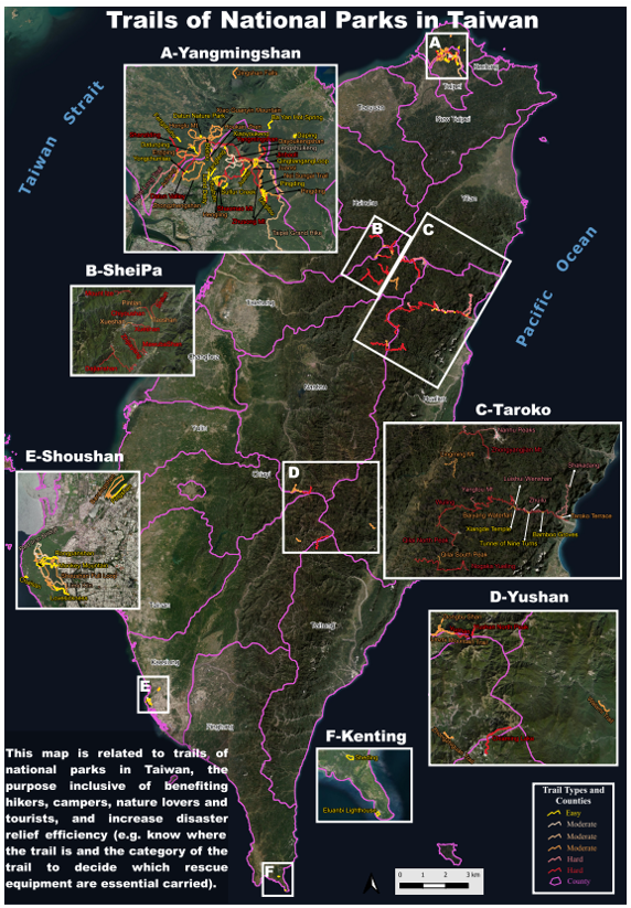
Link: https://drive.google.com/file/d/1iD0H5g8c6CO6_sMhdgFAGq67yd3vCDsr/view?pli=1
Making the trails map of National Parks in Taiwan, which should be useful for hikers, campers, nature lovers and tourists. Furthermore, I think it can help rescuer know more detail about the trail and increase disaster relief efficiency.
2022 Starlink service map with population benefit
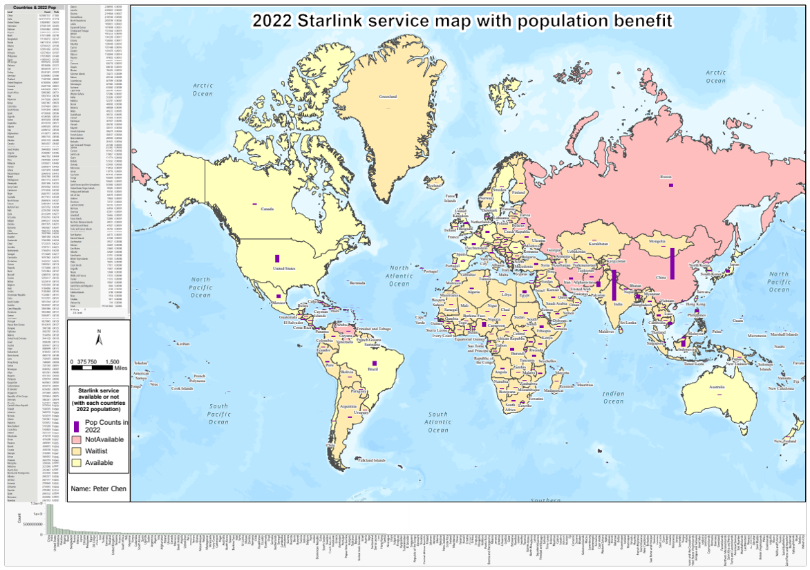
Link: https://drive.google.com/file/d/1SOUj0_Mal5wMbi2ds9pOREuutoGLJwYy/view
Starlink is well known for its satellite internet and communication, which plays an important role recently (e.g. the war between Russia and Ukraine) and in the future (e.g. 6G internet). Therefore, it’s essential for us to know which countries are available to apply for the service, and we can clearly know by using GIS (Cartography). This map shows which countries are available to use Starlink service now or in the future, and countries that aren’t able to use the service. Furthermore, it is able to figure out how many people in each country are possible to use the service in 2022.
Choropleth Map
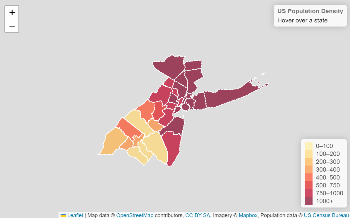
Link: https://chiyuchen.github.io/Chanllenge3_choropleth-map/
A choropleth map is used to visualize and communicate the spatial distribution and variation of a particular variable, such as population density, by using different colors or shades to represent different levels of the variable. It can quickly highlight areas with high or low values, and help identify patterns or trends across regions. This type of map is commonly used in fields such as geography, sociology, economics, and public policy to analyze and present data on various social and economic phenomena, and to inform decision-making and policy development.
Proportional Map
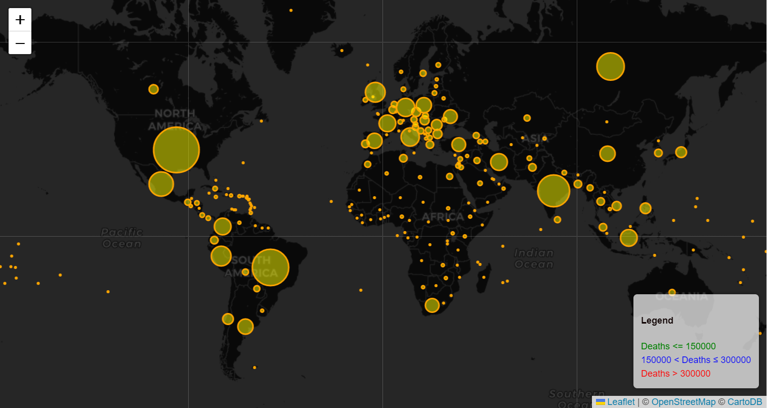
Link: https://chiyuchen.github.io/Challenge3_proportional-symbol-map/
A proportional symbol map is used to visualize and communicate the spatial distribution and variation of a particular variable, such as population, by using different sizes of symbols to represent different levels of the variable. It can quickly highlight areas with high or low values, and help identify patterns or trends across regions.
Honors and Skills: Anchors of Achievement
Throughout this journey, I’ve been fortunate to receive recognition for my efforts. From annual Military Commendations to a First Prize in Academic Record, these acknowledgments have fueled my drive to excel. The challenges I’ve embraced have shaped my skill set, ranging from SketchUp and ArcGIS to Microsoft Office, forming a comprehensive toolkit to tackle geospatial intricacies.
As I continue to navigate the geospatial realm, my heart brims with excitement for the uncharted territories that lie ahead. GIS isn’t merely a profession; it’s a passion that propels me to unravel the mysteries of our world, one map and analysis at a time. Join me as I forge ahead, driven by an unwavering commitment to charting new horizons in the world of Geographic Information Systems.